FieldMove: A Digital Field Mapping App for Geologists
Screenshots
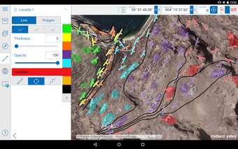
FieldMove is a free digital field mapping app designed by Petroleum Experts Limited for geological data collection. This app is primarily used on larger touchscreen tablets and is presented in a map-centric format to create geological boundaries, fault traces, and other linework on your basemap. It also provides the option to create simple polygons to show the distribution of different rock types.
One of the most impressive features of FieldMove is its support for Mapbox™ online maps that can be cached to work offline in the field. Geo-referenced basemaps in MBTile or GeoTIFF format can also be imported and are available offline when working in the field. Additionally, this app allows you to use your tablet as a traditional hand-held bearing compass and as a digital compass clinometer for measuring and recording the orientation of planar and linear features in the field. Geo-referenced text notes, photographs, and screenshots can also be captured and stored within the app. Finally, FieldMove contains a library of geological symbols that enables data to be plotted on a stereonet, which allows the user to carry out analysis based on their field observations and measurements.


