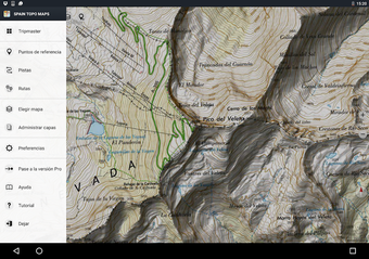
Tenerife Topo Maps: A Comprehensive Navigation App for Android
Screenshots
Tenerife Topo Maps is a free navigation app for Android phones and tablets developed by ATLOGIS Geoinformatics GmbH Co. KG. This app provides offline and online mapping capabilities, allowing users to access topographic maps and aerial images of Tenerife. With multiple map formats available, including topographic, satellite, and aerial views, Tenerife Topo Maps is a versatile tool for outdoor enthusiasts.
Designed for outdoor activities such as hiking, biking, camping, climbing, skiing, and more, Tenerife Topo Maps offers a range of features to enhance the user experience. Users can add waypoints using various coordinate systems, including longitude/latitude, UTM, MGRS, and USNG coordinates with a WGS84 datum. This makes it easy to navigate and plan routes accurately.
One of the standout features of Tenerife Topo Maps is its suitability for search and rescue (SAR) operations. The app provides essential information and mapping tools that can assist in emergency situations. Whether you're an avid adventurer or a professional in need of reliable navigation, Tenerife Topo Maps is a valuable resource.


